¡Bienvenidos a Guatemala!

We were asked the question so often that we had to stop to consider it ourselves: "Why did you decide to go (or come) to Guatemala?"

While there's no definite answer, when you consider all the factors that come into play while visiting a foreign country, it's easy to respond with an equally ambiguous "Why not Guatemala?"

Thus far in our lives, we haven't exactly selected the traditionally sunny, romantic or heavily touristed vacation destinations. Our interests don't lie on sunny beaches and tiki bars nor upon aged white-washed walls overlooking sunset seas and rustling vineyards. We can't say that the Statue of Liberty or the Eiffel Tower occupy must-see spots on our travel lists, although we by no means shirk the idea of traveling to such places.

So, why Guatemala?

Guatemala is a country whose colonial history extends further back than that of the United States, and its Mayan history far precedes that of much of Western Europe. Like much of Latin America, it has endured a troubled colonial past and these centuries-old tensions remain apparent in much of the culture: Spanish is the official language, the government administration and bureaucracies are identifiably Spanish and the major cities have distinctive Spanish architecture. And yet a vast majority of the population are of pure, native Mayan descent and the true character of the country isn't its Spanish influence but the underlying - and still very much alive -Mayan culture.

If you're having trouble grasping why two people from Minnesota would be fascinated by a country torn between a native people and colonists, there are simpler reasons for visiting Guatemala other than its history:
  • Guatemala is a geological marvel.  Massive rolling hills encapsulate cloud forests and allow several micro-climates to exist within miles of each other. You can't swing a dead cat without hitting a volcano (active or dormant) and deep lakes that foster and breathe life into much of the countryside are pocketed throughout the landscape as a result of its continuous volcanic eruptions and intermittent earthquakes.
  • Guatemala has ancient ruins.  As far as ruins go, Guatemala has by far the most to offer the tourist who is interested in the Maya. In addition to Tikal (hands down the most impressive Mayan city that still stands), Guatemala is sprinkled with countless ruins. While Mexico and Honduras are also home to Mayan ruins, Guatemala has not only the majority but also the most historically significant ones.
  • Guatemala is warm.  Immediately this appeals to snow-stricken northerners like ourselves. While winter continues to plod on in Minnesota, Guatemala is in its dry season or el verano (summertime) at this time of year. As a result of its tropical geography, Guatemala is often referred to as the mecca of tropical fruit by numerous travelers. Every city of significant size offers open air markets where locals sell an array of fruits - some familiar, such as strawberries, bananas, pineapple and mangoes, and some not so familiar, such as jocotes. While bartering for fruit in a busy market may not be the same relaxing atmosphere as sipping a piña colada on a beach, it does offer a lot more in the way of variety and freshness!
  • Guatemala is friendly and a great place to work on your Spanish. Forget what you've heard about Guatemala's reputation. Yes, there is violence, however, it has an emerging tourism industry and most locals in places like Antigua and Xela are quite accommodating of tourists who approach them respectfully. Spanish helps, but is not truly required. The Spanish spoken in Guatemala is quite clear and devoid of confusing dialectal forms or heavy accents, therefore an intermediate level of Spanish will go a long way here.
  • Guatemala is inexpensive.  Hotels and hostels are abundant in most major cities and a few hundred US dollars will put a roof over your head for weeks or even months. Food is even cheaper. While quality restaurants are of comparable price to fast food chains in the United States, street food and food purchased in markets are so cheap that you can eat three meals a day for under $5.
Beyond these reasons, there is a lot to do in Guatemala and the answer to the question really lies in one's personal interest in geography and culture. So when asked the question of "Why Guatemala?," we found the best answer to be simply, "Because it has always fascinated us."

La Antigua Guatemala

We landed in Guatemala City, capital of Guatemala, shortly after noon. We promptly boarded a shuttle for Antigua and didn't look back. After traversing the busy city streets of the capital and gradually climbing up the winding hillsides that seem to fence in the chaos, we were surprised that about forty minutes from the airport we had found ourselves in a completely different world: La Antigua Guatemala which literally translates to "the old Guatemala" or "the ancient Guatemala."


A gem of Spanish colonial architecture, Antigua was founded in 1527 as the third capital of Guatemala largely due to Maya uprisings. Throughout its history it has been repeatedly destroyed by volcanoes, earthquakes, lahars (landslides) and floods and yet rebuilt time and time again. Although no longer the administrative capital of the country, it is in essence the tourism capital and a mandatory stop for any traveler in the area.

Antigua is chock full of landmarks. It has countless cathedrals, many of which come in the form of preserved ruins and many of which are fully functional, still standing places of worship. Its bumpy, uneven cobblestone streets slither and snake through angular cuadras of buildings squeezed together without so much as a glimpse of an alleyway, lawn or garden in between. The Arco de Santa Catalina, built in the 17th century, serves as one of the most iconic landmarks of the city and, in our case, as an indispensable aid in orienting the fresh tourist.

Arco de Santa Catalina
We spent our first two days in Antigua as an orientation to Guatemala, familiarizing ourselves with the somewhat tourist-saturated local culture and the three massive volcanoes that dominate the hilly landscape around the city: Volcán de Agua, Volcán de Fuego and Volcán Acatenango. On our second day a bus tour brought us around the city to see some of the most impressive church ruins, a coffee plantation and the famous Cerro de la Cruz, another landmark that overlooks the city and puts both the entire city and the perspective of the Spanish colonists into scope.

View of Antigua from Cerro de la Cruz (hill of the cross)
Volcán de Agua (inactive) is in the background, clouds covering the top
La Merced church
Church ruin
Matt and his favorite beans - coffee, that is
As we were to learn with most major cities in Guatemala, the mercado central is a mandatory stop. The hoards of gringos disappear and are replaced by locals plying fresh produce and other food in the open air market, and the comedores have simply the best prices in town to get a filling, delicious meal. Most day-to-day items can be purchased here, including clothing, toiletries, household cleaners, tools and other supplies, but we had to stick to the fresh fruit section. When you can buy a couple pounds of mangos and bananas for about one US dollar, you'll find yourself furiously eating the fruit in order to give you a reason to hurry up and go back to buy more.

Quetzaltenango (Xela)

We boarded a shuttle bus outside our hotel in Antigua at 5:30 AM, and long before the sun rose we were climbing through the sloping hills towards Quetzaltenango, better known by its indigenous name, Xela (SHAY-la). Our stomachs lurched as our shuttle swerved around endless hillsides on the Pan-American Highway until we reached Xela about three and a half hours (and two shuttle transfers) later.

Even older than Antigua, Xela was originally a Maya city and is said to have been at least 300 years old when the Spanish first arrived in the 1520s. The Spanish didn't waste any time in conquering the city and laying their own foundations, which now sprawl unevenly across the hilly terrain. The streets of Xela, winding up and down hills with buildings impossibly stacked upon each other, are faintly reminiscent of San Francisco, California.


Xela is the administrative capital of Guatemala's western highlands and, unlike Antigua, is less geared towards tourists and more geared towards business. That aside, there is still a definite gringo presence in the city. It's renowned for its Spanish language schools and there are numerous agencies that facilitate hikes and similar adventures around the countryside, which, like most of Guatemala, are dotted with volcanoes.

We spent the greater part of the day wandering through the city streets, admiring the Parque Central and visiting one of the many mercados in the city. Later in the evening we received a pre-hike orientation from Quetzaltrekkers, the group responsible for organizing our backpacking adventure.

Mercado, Xela
Parque Central, Xela

Highlands Trek, Day 1 - Xecám to Ixtahuacán

The next three days would be spent backpacking across the western highlands with four guides and 20 fellow trekkers whose age spanned early twenties to early sixties and whose nationalities included Scottish, Australian, Czech, Kenyan, Canadian and American.

The first day of the trek began with a pancake breakfast at Quetzaltrekker's office in Xela. With our packs fully loaded with personal belongings, two liters of water each and our allotment of the group's food for three days, we departed, crossing Xela on foot until we reached the Minerva bus terminal, at which point we loaded our packs on top of a chicken bus and burnt rubber.

Forty minutes later we arrived in Xecám (shay-KAHM), a small Mayan village outside Xela and began our 45-kilometer (28-mile) trek across the highlands of western Guatemala. The ending point would be Lake Atitlán three days later...

The first two hours of the journey took us up a fairly steep mountain, at the top of which gave way to pastural farmlands where local Maya farmers were busy working as we plodded along a narrow pathway through their fields.


The farmland faded away as we found ourselves high atop hills that curved and sloped downwards into thick cloud forests far below. To sit on a rock and look downwards as clouds ebbed and flowed through lush forest like water was simply breathtaking and something we had never experienced before.


Shortly after lunch, the rain began to fall. Fortunately, it was a light rain, but it did persist the rest of the day. We descended the hills and marched the last few miles along a gravel road that brought us through a few small communities until we arrived in the mountain village of Santa Catarina Ixtahuacán (eesh-tah-wa-KAHN).


Shelter for the night was the humble community center. After dinner and hot beverages, we threw our bedrolls, sleeping bags and weary bodies down upon the hard tile floor and tried to get some rest. Rest was fitful, however. We turned like rotisserie chickens on spits trying to find a comfortable sleeping position (which proved elusive). Add to that the symphony of crowing roosters and village church bells tolling on the hour and you can understand why we welcomed the breaking dawn.


Highlands Trek, Day 2 - Ixtahuacán to Xiprián

The next morning we wasted no time in peeling our aching bodies off the hard floor and packing up our stuff. At the local comedor (small restaurant), local Mayan women graciously fixed us a breakfast of rice, beans and eggs, as well as café - which we learned doesn't necessarily mean coffee but rather, referring to the most literal translation of the word, brown water. It's interesting to note that Guatemala produces some of the best coffee in the world, but the native population has little to no interest in it.

We continued on along the gravel road that had brought us into the village the night before. Now it edged upwards along the side of a mountain, and around the bend, it revealed our next task: scaling a short but steep hill...in record time!


The fastest recorded time this hill had been climbed was by a native Guatemalan who completed it in approximately nine and a half minutes. A handful of the men in our group decided to pit their bodies and backpacks against the fastest of the fast. While the fastest in our group clocked in at just over 11 minutes, Matt clocked in at just over 12 minutes. Not too shabby!

(Tara was "close behind" - but no less victorious - at approximately 25-30 minutes)
Panting furiously at the top of the small climb, we paused for a break before continuing upward for the next hour. This was the most grueling "uphill" of the trek, made somewhat more intense by the sun, which had long burnt off the morning clouds and was now shining in full force.

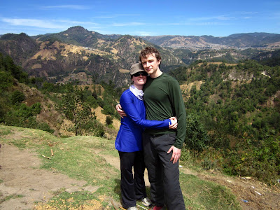
From this vantage point, we could see the highest point of the Pan-American Highway (10,334 feet)
Finally the terrain leveled off and we continued onward through more Mayan villages, across beautiful farmlands with checkered fields of green and gold.


After a lunch of rice, black beans and avocados, we hiked on for several more hours, arriving at late afternoon at the house of Don Pedro in the Maya village of Xiprián (ship-ree-AHN). He had prepared licuados (smoothies) of strawberry and pineapple for his weary guests, which was soon followed by a delicious meal of grilled chicken, tomalitos, rice, beans and vegetables.


After some brief entertainment round the family's outdoor fire, we tucked away in a large spare room of the family's house where another night of "sleep" awaited us.

Highlands Trek, Day 3 - Lago Atitlán

We rose before dawn (4 AM) to conquer the remaining five miles of the trek, pausing at a mirador (overlook) for breakfast and to see the spectacular sun rise over volcano-rimmed Lago Atitlán, our ultimate destination and perhaps the most spectacular natural wonder in all of Guatemala.

We made it to the overlook while the sky was still black and the cities along the lake shore and the skirts of the mountains still glittered with streetlights. In the distance, Volcán de Fuego, the active volcano just outside of Antigua, was erupting: a plume of black smoke flowed like an oily ribbon from its crater while the red glow of lava belched into the early morning sky.


The guides, who do this trek every weekend, had never seen lava so prominent as it was right then, which was pretty cool to hear (as if this otherworldly sight hadn't already rendered us speechless).


We relaxed at the overlook and took in the vista of the lake as the sun slowly made its appearance and the glitter of streetlights and fiery glow of the volcano faded into daylight. Daylight revealed ferries and other watercraft, appearing as tiny insects skating along the surface of the lake, as well as the depth of all the hills, mountains and volcanoes surrounding us. Toto, we're not in Kansas anymore...


After fueling up with oatmeal, granola, jam and peanut butter, we descended into the lakeside city of San Juan La Laguna. Like all the descents of the trek, it was steep, steep, steep and somewhat slow-going. You had to watch every foot fall to ensure your stability on the rocky, sandy incline. The views as we wove down the mountainside were utterly spectacular, though. I will let the pictures speak for themselves...


Looking up and back from where we had come...
This is "Indian's Nose Trail" - can you see why? (Hint: he's lying down)
The shores of Lake Atitlán are terraced with coffee plants - it was so neat to walk through them on the way down.


In San Juan, a camioneta (small truck whose bed is meant for transporting people) was waiting for us. We crammed in like a pack of dirty clowns and were whisked away to the neighboring lakeside town of San Pedro La Laguna where we ate one last meal together as a group at a beach-y cafe/hotel called Casa Blanca. Shedding our packs on that patio never felt so good. We had made it.

Panajachel

We had booked a room across the lake (and about six miles away) in Panajachel (pah-nah-ha-CHEL) for the night, so our next move was to get there.

A ferry was the obvious way to go, in terms of cost and timing (the road around the lake is rugged and slow), so it wasn't long before we were bumping over the white caps of Lake Atitlán towards a much-anticipated, beyond-luxurious-at-this-point, hot shower.


And luxurious it was. Lo and behold, beneath the layers of sunscreen, sweat, grit and dust, Matt and Tara were (miraculously) still there! If only we had thought to take "before and after" photos...

Clean and rejuvenated, we soon found ourselves wandering the whimsical, tropical town with a furious appetite. Luckily, we weren't the only ones - another couple from the trek, Stuart and Tina from Oakland, California, had joined us in Panajachel and we met them for dinner at the Sunset Cafe, located right on the water.


The show did not disappoint, nor did the conversation. Stuart and Tina have been traveling in Mexico and Central America for seven months and will continue on to El Salvador, Nicaragua and Panama, eventually ending in Colombia; hearing about their experiences (and about previous trips to Southeast Asia and India) was fascinating. Three liters of Gallo later, we ambled back to the hotel and practically melted into the mattress. Oh, the wonders of a mattress...

Mayan Ruins of Iximché

With less than 48 hours remaining on our trip, it was time to see some Mayan ruins. Iximché (ee-sheem-CHAY) was the natural choice as it was located almost exactly between the lake and our lodging in Antigua for the last night of our stay.

Perched in the highlands amid pine-oak forest, Iximché was the capital of the highland Maya kingdom of the Kaqchikel (ca-chee-KELL) from 1470 until its abandonment in 1524 (guess who arrived that year). It was called Guatemala by the Spanish, from the Nahuatl Quauhtemallan meaning "forested land." Since the Spanish founded their first capital at Iximché, they took the name of the city used by their Nahuatl-speaking Mexican allies and applied it to the new Spanish city and, by extension, to the kingdom. This is how the country got its name.

While Iximché is certainly a lesser known site than the previously mentioned Tikal and Copán (just across Guatemala's eastern border in Honduras), it held enough ancient mystique to keep us there for over two hours, wandering amid the crumbling ruins of pyramid-temples, plazas and ball courts...imagining "what was" and contemplating "what if..." This is why travel is so enriching. Places like Iximché - and Guatemala in general - give you a true sense of history and the passage of time.


The smell of incense and the faint sound of drumming drew us to the back of the site where a couple dozen local people had gathered for what appeared to be a sacred ceremony. Men smoked and women knelt and offered up fruit. We didn't quite "get it," but it did prove what we'd heard time and time again while in the highlands - that the ancient Maya culture, though ravaged through time, is still very much alive in 2013.


Adios, Antigua

Though we had left Antigua just five days earlier, it seemed like it had been two weeks. It felt great to be back - maybe because it was the first place we had stayed or maybe because Antigua is just Antigua...teeming with color, charm and friendliness.


We'll leave you with the view from our hotel's rooftop, the roof that launched a thousand photographs. This time we were able to see the full silhouette of Volcán de Agua, it's top no longer hidden in the clouds.

Good night, Volcán de Agua
Good night, Volcán de Fuego and Volcán Acatenango

Now...don't you want to go to Guatemala, too?